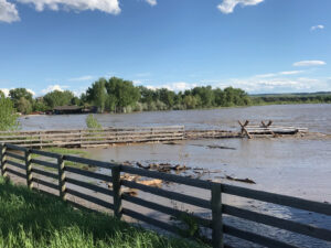
Yellowstone River flooding over the banks Thursday afternoon @ 6pm near Cowboys in Huntley. In front, an animal corral and fence is losing ground due to erosion as water levels increase approaching the Memorial day weekend. (Jonathan McNiven photo)
UPDATED: This Emergency Flood declaration was just issued by Yellowstone County Disaster and Emergency Services spokesman Brad Shoemaker at 4:35pm on Thursday May 24, 2018.
The National Weather Service has issued a forecast for the Yellowstone River and Clarks Fork of the Yellowstone River which indicates MAJOR FLOODING beginning following a significant rainfall event on Sunday May 27th. The Yellowstone River is forecasted to rise nearly another 4’ from its current levels to 16.4’ by mid-next week. This would set a new record crest from the river, the current record crest is 15.0’ set in 1997. Impacts from this level of water may include widespread flooding, bank erosion, channel migration, road and bridge closures, power outages and impacts to services such as water and sewer systems. The Clarks Fork of the Yellowstone River is forecasted to rise another 2.3’ from its current level to 10.8’ by mid-next week. This would set a new record crest from the river, the current record crest is 9.3’ also set in 1997. Impacts from this level of water in Yellowstone County may include widespread flooding, bank erosion, channel migration and road and bridge closures. Across all of Yellowstone County, residents should also expect to see flooding of small streams such as Canyon Creek, Blue Creek, Alkali Creek and Pryor Creek due to heavy rainfall. This may also result in breaches of irrigation ditches and other systems that transport or hold water. Operators of such water systems should monitor their areas for signs of breaches and failures. Yellowstone County will be placing sandbags and sand at locations around the community over the next couple days. Residents will need to fill the provided bags Sandbags and Sand will be available near the end of the week at the following locations: Huntley Fire Station, Worden Fire Station, Blue Creek Fire, Station Laurel Soccer Field at Fir and East Maryland Rd.

