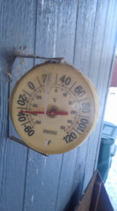
Wes Prouse of Shepherd photographed a thermometer at his home this week. ‘This is for everyone bragging about your wind chill,’ he posted with the photo. ‘This is real temperatures.’ (Courtesy Photo)
HUNTLEY — The temperature keeps falling, and so does the snow.
Mix in some wind and it all adds up to a tough winter — closing schools, closing highways and making it tough for ranchers, livestock, wildlife and anyone who has to shovel.
By this week, February saw more snow than any year before.
By Feb. 18, 31.5 inches of snow had fallen at Logan International Airport in Billings. Meteorologist Aaron Gilstad at the National Weather Service office in Billings said that’s the most through that date, and the record for the entire month of February is 37 inches, recorded in 2014.
“So we’re on pace to surpass that fairly easily,” Gilstad said, if the current weather pattern continues through the end of the month.
That pattern is an upper level Pacific jet stream “impacted by a polar jet as well,” Gilstad said. “They ran into each other right over the top of us,” wringing out moisture combined with cold to dump snow across the region.
There’s a respite from the snow this week, he said, although cold will linger through the weekend.
“All this week we’re expecting it to be fairly dry and fairly cold,” he said.
Since October, he said, 76 inches of snow have fallen at the Billings airport. The previous record for that time period was 72.3 inches and the snowfall record through the end of February is 90.2 inches, recorded from October 2013 through February 2014.
“We’re well ahead of schedule,” Gilstad said, about 11 inches ahead of 2013.
Tuesday’s forecast called for bitter cold and high winds, with wind chills as low as 45 degrees below zero. That prompted school officials in Billings, Lockwood, Pioneer, Independent, Shepherd, Huntley Project and Custer to close schools. Winds were not as strong as forecast. Area students returned to school on Wednesday, although not without problems.
“We tried to run buses this morning,” said Custer Superintendent David Perkins on Wednesday. “The first one had to return. The driver reported -28 when they came into town. Not all the thermometers showed that; but, with a bus not making it, that is it. No buses in the morning (Thursday).”
Shepherd and Huntley Project students returned to class on Wednesday.
HP Superintendent Mark Wandle issued a statement thanking students, parents and patrons of the district during the recent bad weather and days out of school. The district made up one missed day by attending school Feb. 16, waived one day and used a state law allowing districts to declare an emergency to cover another missed day. Students may have to make up Tuesday’s missed classes, to be discussed by the school board on March 12.
“Your support has been appreciated,” Wandle said in his statement. “The Huntley Project School District knows the inconvenience caused when we do not have school in session. We do not take calling off school lightly, but we will continue to have the safety of our students and staff at the forefront of our decisions.”

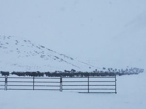
Snow-covered cattle move across a Ballantine-area farm, above, in this photo taken Sunday, Feb. 18. Temperatures are expected to warm up slightly over the weekend, but lows will remain in the single digits and a chance for snow will develop by Sunday, although that system was ‘too far out and disorganized’ for a detailed forecast at presstime, National Weather Service meteorologist Aaron Gilstad said this week. (Photo courtesy of Marc Shaules)
Wandle said “the past couple of months have helped our district to reevaluate ways to improve school procedures for the future.”
Gilstad said continuing mountain snowfall will add to an already deep snowpack, which could lead to runoff concerns later in the spring and summer. Forecasters expected snow to continue in the Absaroka, Beartooth and Big Horn mountains through the week, although little was expected to make it into the plains.
Cooke City has received 170 inches of snow since November, Gilstad said, and a couple feet fell there last weekend (Feb. 16-18). Mountain snowpack in the Cooke City area is 200 percent of the 30-year average at some sites, Gilstad said, although the moisture level may vary and it’s hard to estimate spring runoff at this point.
Also, snow that falls in March or April generally contains more moisture, he said. The Bureau of Reclamation is tasked with estimating runoff to maintain water levels in a series of reservoirs on the Big Horn, Shoshone and Wind rivers, several of them in Wyoming, but which will likely affect Montana irrigators, he said.
Meanwhile, ice piles up on are rivers, but Gilstad that’s normal for this type of weather pattern and ice jams and potential flooding have not been a concern to this point.

