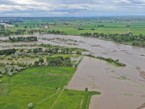
The Yellowstone River is running out of its banks in this 6/13/22 drone image near Shepherd at Arrow Island. More Drone images at end of story. (Drone image by Jonathan McNiven)
As of 5 pm on Monday, June 13, the National Weather Service issued flood warnings for the Yellowstone and Stillwater Rivers. The warning follows two days of significant flooding of streams at higher elevations – flooding that is devastating the town of Red Lodge and has closed roads in numerous places including Yellowstone National Park, the upper Stillwater, and the highway between Gardiner and Livingston.
Flood levels measured on the upper Yellowstone River are beyond record levels.
Flooding is threatening the town of Joliet and residents are being asked to prepare for evacuation.
Some reports claim that the Clarks Fork River is at record flood levels.
Rock Creek in Red Lodge has broken through its banks and waters are flooding more than half the town from the creek at the town’s eastern edge to beyond Main Street where river water is flowing two feet deep.
Yellowstone Park announced that it read more

