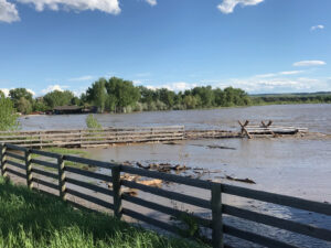
Yellowstone River flooding over the banks Thursday afternoon @ 6pm near Cowboys in Huntley. In front, an animal corral and fence is losing ground due to erosion as water levels increase approaching the Memorial day weekend. (Jonathan McNiven photo)
With warm temperatures melting a heavy mountain snow pack and a forecast for heavy rain beginning Sunday, state and county emergency services are scrambling in anticipation of record flooding by Memorial Day, if not sooner. They are especially concerned about the impact on Huntley.
The Yellowstone River and some of its tributaries are expected to exceed record levels of flooding, following storms that are forecasted to dump as much as two inches of rainfall along the Beartooth front and the Pryor Mountain foothills. Officials projected that some rivers, including the Yellowstone River at Billings could exceed record flooding by 1.5 feet or more, as the rainfall augments river levels that are already at normal flood stage. “It has our attention,” said Keith Meier, a meteorologist of the National Weather Service, Billings, indelivering the forecast on a phone speaker during a press conference Thursday afternoon.
“There’s going to be a lot of people who have never seen flood waters before, getting flooded,” said Brad Shoemaker, County Emergency Services Director. The Yellowstone River is expected to be at minor flood stage of 13.5 feet by Monday – rising to 16.4 feet by late Tuesday or early Wednesday. The record for flooding on the Yellowstone at Billings was set in 1997 at 15 feet.
County Commissioner John Ostlund said that it is urgent that they get the word out to people.
Emergency service providers and public works officials, for city and county, joined the press in the county commissioners’ board room to hear projections from the Weather Service regarding the potential of flooding. There was subtle tension among the officials, who said that the situation is one in which they are likely to have to deal with problems not seen before, and they are trying to anticipate some of them in advance.
Getting equipment and materials in place to be able to shore up the Yellowstone River bank at Huntley is one of their priorities, according to Tim Miller of the County Public Works. They expect to see the river attempt to break its banks at the Cowboy Bar in Huntley. It could also flood across the road and flood Nahmis Avenue.
There will be other points of flooding but none will threaten as many residents as at Huntley.
Another area of great concern is the Clarke’s Fork River, where flooding is also expected to reach levels never before experienced. The river could forge a new channel at that point, speculated Ostlund, who reiterated the importance of making sure everyone is made aware of the threat posed.
There will be issues for the City of Billings relating to its water intake and to its sewer treatment plant. They are likely to have to pump treated water into the river from the plant, if high waters make normal discharge impossible, explained City Public Works Director Dave Mumford. At that point the Northwest Energy substation will probably be underwater and the treatment plant will have to rely on generators.
The city may also have to shift their water intake to a location further out in the river, which will reduce the amount of water the city will have. But that won’t be so much of a problem since people probably won’t have to water their lawns, said Mumford, with something of a wry smile.
Mumford said that once the Yellowstone River reaches flood stage storm drains start flowing backward. In fact, “it was beginning to do that yesterday,” said Mumford about the heavy rain and hail that hit Billings Wednesday afternoon.
He was asked if the back-flow could be enough to lift man-hole covers. “Yes!” Mumford replied, pointing out that backing up storm drains could cause problems for people in the city who don’t normally anticipate having issues with flooding.
Underpasses will also be quickly flooded, said Mumford.
The Yellowstone County Public Works Department has ordered 50,000 sand bags, which will be available to anyone who needs them – they just need to pick them up at fire stations in Huntley and Worden and Blue Creek; and the Laurel soccer field at First and E. Maryland Road.

